
.jpg)
.jpg)
.jpg)
.jpg)
.jpg)
.jpg)
.JPG)
.JPG)
.jpg)
Nearby structures
Umbria, Rivotorto di Assisi (PG)
COUNTRY HOUSE LA PADRONALE DEL RIVO
Umbria, Passignano Sul Trasimeno (PG)
HOTEL CAVALIERI
Tuscany, Chianciano Terme (SI)
HOTEL SOLE & ESPERIA
Tuscany, Chianciano Terme (SI)
GRAND HOTEL TERME
HOTEL MAMIANI
HOTEL GABBIANO
HOTEL AMBASCIATORI
Emilia Romagna, Cattolica (RN)
HOTEL CARACAS
Emilia Romagna, Cattolica (RN)
HOTEL PHILADELPHIA
Emilia Romagna, Cattolica (RN)
HOTEL D'ANNUNZIO
Located just 8 km from Perugia and 15 km from Assisi and other places of interest, it is located in Ponte Valleceppi, completely immersed in the Umbrian countryside in a strategic position, close to the E45 (Cesena - Roma)
The rooms are equipped with private facilities, satellite TV, telephone, air conditioning and parquet floor, underfloor heating
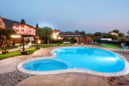
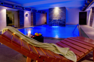
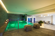
There is a restaurant, a bar, a 24-hour reception, an outdoor swimming pool, a TV room, a large garden, wi-fi throughout the hotel, a car park (until seats are exhausted)
Check in : from 2 pm to 6 pm
Check out : from 07.00 am to 11.30 am
Small pets are allowed upon notice at the time of booking
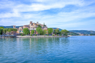
The historic center of Perugia lies on an acropolis that rises up to about 450 m asl. At the highest point, Porta Sole, the height is 494 m, which makes it the most populated Italian city among those at an altitude of over 250 meters. The old town develops around this point and on the ridge of the hills that leave it, forming an acropolis and five medieval villages extended on five gates. At the original 3 km long Etruscan walls, in the 13th and 13th centuries, a new and definitive 9 km long, almost completely integrable, surface area of 120 hectares was added. The historical town is therefore predominantly stretched on the ridges, with an almost elliptical shape with a greater axis of 3 km between Monte Ripido (north) and San Costanzo (south) and a smaller axis of 1,5 between S. Francesco and Monteluce . The historic districts are: Porta Sole, Porta Sant'Angelo, Porta S. Susanna, Porta Eburnea and Porta S. Pietro, to which they had for centuries their respective rural areas, subject to the city since the times of the municipal government. Each neighborhood encapsulates on a main street or course on which the alleyways converge; there are monasteries, churches, basilicas, churches, oratories, chapels, gentle buildings (a hundred), smaller buildings and other buildings, then there are row houses in the alleys. The territory beyond the historic center goes down all the way up to 280 m asl of Pian di Massiano. The territory of the commune reaches 170 m asl, touched along the river Tiber, southwards marking the boundaries with the municipality of Torgiano. Perugia is located in the hinterland of Central Italy, at the widest point of the Peninsula. It is the largest city between Florence and Rome, located in an intermediate position: about 150 km from Florence, Rome and Ancona, about 400 km from Milan, Genoa and Naples. The Perugia acropolis seems to be built on a single hill but in reality there are two: the hill of the Sun and the Landone hill. The maximum depression between the two hills extends from the ditch of Santa Margherita, to the east, to the ditch of Cupa, to the west. The Etruscans chose this area as being rich in water, but it soon became clear that the land was also frantic, which in the centuries has consistently given rise to powerful foundations and fortifications, which still persist in more places. North Mount Tezio and Acuto mountain separates them from the town of Umbertide, to the west a flair of territory comes to touch the hills that surround Lake Trasimeno. In the east, the first hilltops of the Umbro-Marchine Apennines divide it from the communal territories of Assisi and Gubbio.


Robytour s.r.l.
VAT number 02286100595 SDI: KRRH6B9
Cap.Soc. 200.000,00 € interam. versato
Licenza n° 25-33794 del 19/05/2008 Rilasciata dalla Provincia di Latina
Registered office:
via Appia Lato Napoli 220
04023 - Formia - LT


da PAMELA S. - 25/09/2015, alle 08:50
Accoglienza,pulizia,cibo ottimo;punto strategico.Da rifare assolutamente.
Ottimo Hotel,Grazie!
da Barbara t. - 12/12/2014, alle 06:45
da Roberto S. - 01/05/2014, alle 09:38